The shape of Prospect Hill
After the volcanic activity which determined the basic structure of Prospect Hill so many million years ago, erosion gradually wore down the covering layers of shale and left the hard dolerite obtruding in an oval-shaped ridge.
|

But what did it then look like, say in 1788, before any Europeans had seen it? Clearly the shape of the Hill has been substantially changed by quarrying since then. So I thought that I should find out what Prospect Hill looked like before quarrying started. Did it in fact have a "caldera shape" originally, as discusssed on the Geology page, or has the area inside the ridge been so hollowed out by quarrying that it has attained that shape in the last 150 years or so?
The records of the original land grants of 1791 were recorded on maps which show the boundaries of each grant (see the page on Settlement). While there are problems aligning these with the present-day maps, it is clear that some of the grants were for land inside the U or J shape of the ridge. This soil must therefore have been fertile enough and the slope gentle enough for cultivation. The question in my mind was this: was the inside actually higher than the present ridge, was it more or less level with the ridge making Prospect Hill a plateau, or was it lower than the ridge justifying the description of a caldera shape?
The map shown here shows that by 1926 quarrying had not started to destroy the overall shape of the Hill. The ridge has not ye been breached to form the "gap" at its southern end and so is still continuous from Prospect Lookout, over the hill on whose "crown" stood Grey Stanes, the home of Nelson Lawson, to a large southern summit which is clearly considered to be the main summt of Prospect Hill. William Lawson's home, Veteran Hall, is shown close by the Reservoir but I doubt if it was as close as shown here.
Incidentally the winding route of the Great Western Highway can be traced by the milestones at 18, 19 and 20 miles from Sydney. (20 miles is 32 km.) Prospect Post Office is still standing today (2015) though no longer in business, while the Emu and Prospect Company's branch line railway is shown leaving Prospect Quarry and winding round the Hill to follow Toongabbie Road towards the main line at Toongabbie Station.
|
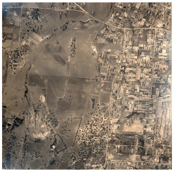
The changes to the shape of Prospect Hill have been greatest in the last thirty years or so, with technical advances making much faster extraction of the rock possible. In this rare aerial photograph taken in 1946, the eastern ridge of Prospect Hill runs down for most of the height of the photo about two-fifths of the way across from the left. Most of the land to the left of this line across to the western ridge, shown by the denser woodland in the SW corner of the photo, still has a pastoral appearance. This is the land that is inside the J shape of the ridge and so it is much like the land outside the ridge, consistent with Prospect Hill having the shape of a shallow dish.
This is consistent with a report by Boral (the present quarry company) stating that, "Early grazing practices cleared the entire hill..." (See quotation). The white patches in the SW quarter of the photo indicate some quarrying, while the enclosure immediately SE of the quarried area can be identified as the paddock of Grey Stanes on the eastern ridge of Prospect Hill.
In Holroyd City Council's Prospect Hill Conservation Management Plan published in November 2005, it is stated that, "Prior to quarrying the centre of the hill was depressed some 46 m below the level of the surrounding ridge." (Holroyd 2005, p 2). 46 metres is a substantial depression. After all, the ridge itself only rises about 50 to 60 metres above the level of the immediately surrounding plain.
So Prospect Hill was a sort of shallow dish before quarrying started. The inside of the dish contained cultivable land probably of similar slope to the outside slopes of the ridge. The quarrying has deepened the dish and steepened the inside edges of the ridge into vertical cliffs of bare rock, making it appear more like a caldera than it had been before quarrying. The deepening has proceeded until land inside the ridge is more or less level and at about the same height above sea level, 70 metres, as the land which surrounds the ridge on its outside. The quarry owners have now (September 2009) just about completed the task of filling in holes and smoothing away the bumps to leave a flat surface for the Southern Employment Lands.
The geology of Prospect Hill points unequivocally to a volcanic origin, even if the "caldera shape" was far less pronounced a couple of hundred years ago than it is today.
The original highest point
The highest point of Prospect Hill today is the summit I have called Greystanes Hill at 117 metres above sea level. (See the Description page.) (Holroyd 2005, p ii). However this is not where the "original" highest point was before quarrying started. It was when I was researching the location of Nelson Simmonds Lawson's home, Grey Stanes, that I found out how much the shape of Prospect Hill has changed in the last fifty years.
We can identify the location of Grey Stanes as being adjacent to the present One-Tree Hill. Indeed, the "one tree", a Moreton Bay fig, is still visible today and is known to have been planted in the paddock of the house.
|

A map of 1964 (Wilshire, 1967) suggests that Grey Stanes was built literally on top of Prospect Hill - at the highest point. It shows three spot heights. Firstly, Water Tower Hill was at 380 feet high (which is 116 metres), Secondly, a point just west of the present Greystanes Hill was at 400 ft. (122 metres). Finally a point near the summit that I have called South Top was shown as 430 feet high. This is equivalent to 131 metres, a full 14 metres higher than the highest point today. Was this then the highest point of Prospect Hill before quarrying?
The 430-foot spot height was contained within a sausage-shaped 400-foot contour loop near the top which I have called the South Top. To the north-east a further 400-foot contour loop is shown. This loop is about the same length as, but wider than, the one at the South Top, which suggests that a summit within it was also about 430 feet. Unfortunately no spot height is shown here. However it seems quite likely that the "original" highest point of the whole Prospect Hill ridge was here, close to One-Tree Hill and about 131 metres above sea level. Moreover the location of this 400-foot contour loop is almost exactly where Nelson Lawson's Grey Stanes stood. So it looks probable that the house that was said to have been built "on top of the hill with views all around" was situated at what was, at that time, literally the highest point of Prospect Hill.
I have now found five references that describe Grey Stanes as being built "on top of" Prospect Hill (1). If there were one or two, one might conclude that this was a vague figure of speech. With five however, one is forced to the conclusion that Grey Stanes was indeed built at the highest point of Prospect Hill.
Of particular importance is the testimony of J Milne Curran who, writing as early as 1899, also gives 430 feet as the altitude of the summit and places Nelson Lawson's home, Grey Stanes, close by.
It came home to me that not only has the whole of the inside of Prospect Hill been quarried away to the same level as the land surrounding the Hill, but the quarrying has also continued outwards from inside the oval ridge right through the ridge crest itself along its southern and eastern ridge. The present crest of the eastern and southern ridge is therefore lower in height and further out from the centre of the Hill than the original crest.
The answer to my question now seems fairly clear. Before quarrying there were two summits that were of equal or almost equal height above sea level at 131 metres (430 feet) above sea level. One was at or near the present South summit and the other was some 500 metres north-east near the present One Tree Hill where Nelson Lawson's house Grey Stanes stood. Five authors have identified the latter as the summit of Prospect Hill. The current NSW Land Dept. map (Prospect map 2001) still shows 130 metre (400 ft) contour loops, although the ridge crest has now been quarried away completely, apparently leaving the present level of the ridge below 117 metres.
A subsidiary summit stood nearly a kilometre further northwards at a height of 122 metres above sea level. This was the site of the triangulation station named Greystanes. This summit disappeared through quarrying, leaving a lower summit about 40 metres east of it with a height of 117 metres (or 384 feet) above sea level. Since the original high points have also been quarried away, this 117 metre summit, which I have called Greystanes Hill, is now the highest point of Prospect Hill. It is 14 metres (or 46 feet) below the height of the original highest point.
The Crown of Prospect Hill - that beautiful hill that is such a landmark for many miles around - is occupied by 'Greystanes' formerly occupied by Nelson, Lawson... (McGowan quoting Frame, 1909)
On the land his father had given him, Nelson Lawson built a beautiful home which he called 'Greystanes House'. The house stood on top of the hill with views all around. One could see the Blue Mountains to the west and look right across Whalan's Farm almost to the sea... (Ambler, 1988)
One of [William Lawson's] sons, Nelson Simmonds Lawson, a Member of the Legislative Council, built that other fine Colonial mansion, "Greystanes" immediately to the east of Veteran Hall and crowning the top of Prospect Hill. (Bloxham, 2002)
A further source from 1958 shows a sketch map of Prospect Hill with its clear J shape. The positions of Veteran Hall and "Greystanes House" were indicated, and spot heights were shown as follows: Greystanes Trig point, 110 metres; Water Tower Hill, 110m; Point just S of Grey Stanes, 130m; South Summit, 130m. Even though these heights are clearly approximatons, the map nevertheless provides evidence that the highest points of Prospect Hill were originally on its south-eastern ridge. (Taylor, 1958)
At Prospect these rocks form a conspicuous and irregularly-shaped hill, which attains an elevation of 430 feet above sea level. From its summit, near Greystanes (the residence of Mr. Wentworth), a very commanding view is obtained of the surrounding country, embracing the City of Sydney, Parramatta, Liverpool, Campbelltown, and the Blue Mountains. (Curran, 1899)
(«)